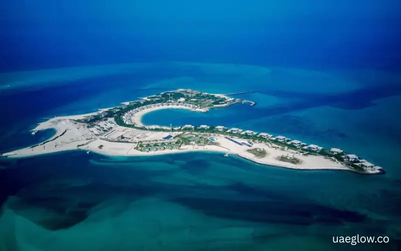
Umm Yifenah Island is an island in Abu Dhabi, United Arab Emirates. It has become closely linked with the Umm Yifeenah Bridge, an 11-kilometre road project that connects Al Reem Island, Umm Yifeenah Island and Sheikh Zayed bin Sultan Street.
The island is not known like Yas Island or Saadiyat Island for large tourist attractions. Its main importance comes from its location, road connections and role in Abu Dhabi’s wider Mid-Island Parkway project. The area also has waterways and mangrove surroundings, which influenced the design of the bridge and its water crossings.
What Is Umm Yifenah Island?
Umm Yifenah Island is part of Abu Dhabi’s network of islands and waterways. The island gained much more attention after the opening of the Umm Yifeenah Bridge in February 2023.
The bridge created a direct transport connection between Al Reem Island, Umm Yifeenah Island and Sheikh Zayed bin Sultan Street. This connection makes the island an important part of Abu Dhabi’s road network rather than a traditional holiday island.
The wider area also connects with Abu Dhabi’s plans for better movement between major islands and mainland areas. The Umm Yifeenah Bridge forms the first phase of the larger Mid-Island Parkway project.
Where Is Umm Yifenah Island Located?
Umm Yifenah Island is located in Abu Dhabi, UAE. It sits within the island and road network that links Al Reem Island with the mainland road system.
One of the most important roads connected to the island is Sheikh Zayed bin Sultan Street. The Umm Yifeenah Bridge provides the main link between this road, Umm Yifeenah Island and Al Reem Island.
Its location also places it within a wider group of important Abu Dhabi islands and districts. Saadiyat Island, Al Raha Beach and Khalifa City form part of the wider Mid-Island Parkway plans.
Umm Yifenah Island Location at a Glance
| Detail | Information |
| Island | Umm Yifenah Island |
| Emirate | Abu Dhabi |
| Country | United Arab Emirates |
| Main road connection | Sheikh Zayed bin Sultan Street |
| Key nearby island | Al Reem Island |
| Main infrastructure | Umm Yifeenah Bridge |
| Wider project | Mid-Island Parkway |
| Bridge opening | 9 February 2023 |
The name may appear online in different forms, including Umm Yifenah Island, Umm Yifeenah Island and Um Yifeenah Island. These spelling variations can make searches confusing, but the Abu Dhabi infrastructure project uses the name Umm Yifeenah.
Umm Yifeenah Bridge
The Umm Yifeenah Bridge is the most important piece of infrastructure associated with the island. Abu Dhabi opened the project on 9 February 2023 as an 11-kilometre connection between Al Reem Island, Umm Yifeenah Island and Sheikh Zayed bin Sultan Street.
The project includes a six-lane highway with three lanes in each direction. It can accommodate about 6,000 journeys per hour in each direction, giving it a total capacity of around 12,000 journeys per hour.
The project also includes walking and cycling paths. Bike rental facilities form part of the project, giving people options beyond travelling by car.
When Did Umm Yifeenah Bridge Open?
Umm Yifeenah Bridge opened on 9 February 2023. The opening marked an important step in Abu Dhabi’s plan to improve road connections between its islands and mainland areas.
The bridge was developed by Aldar in partnership with Abu Dhabi’s Department of Municipalities and Transport.
How Long Is Umm Yifeenah Bridge?
The project covers about 11 kilometres. It includes seven bridges, with two bridges crossing water for a combined length of about 3.8 kilometres.
The project therefore does more than provide one simple crossing. It forms a wider road connection that passes through several parts of Abu Dhabi’s island network.
How Many Lanes Does Umm Yifeenah Bridge Have?
The highway has six lanes in total, with three lanes in each direction. Abu Dhabi states that the road can handle about 6,000 journeys per hour in each direction.
This capacity helps support movement between Al Reem Island, Umm Yifeenah Island and Sheikh Zayed bin Sultan Street.
What Does Umm Yifeenah Bridge Connect?
The main connection can be understood in a simple way:
Al Reem Island → Umm Yifeenah Island → Sheikh Zayed bin Sultan Street
This route helps connect island communities with the wider Abu Dhabi road system. It also forms part of the larger Mid-Island Parkway network.
Umm Yifenah Island and the Mid-Island Parkway
Umm Yifenah Island has a wider role because the bridge forms the first phase of the Mid-Island Parkway project.
The larger project aims to improve connections between several important parts of Abu Dhabi. Official plans include links involving Al Reem Island, Saadiyat Island, Al Raha Beach and Khalifa City.
The planned network also includes walking trails, cycle tracks and sustainable landscape areas. Abu Dhabi announced the wider project with an expected completion target of 2028, so future parts of the network should not be confused with infrastructure that has already opened.
What Is the Mid-Island Parkway?
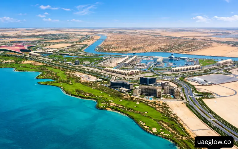
The Mid-Island Parkway is a major Abu Dhabi road project designed to improve connections between the mainland and several islands.
Its network includes roads and bridges that help people move between different parts of the capital. Umm Yifeenah Bridge provides the first completed part of this wider connection.
For people searching for Umm Yifenah Island, the Mid-Island Parkway is therefore an important related entity. It explains why the island has gained greater importance within Abu Dhabi’s transport network.
How to Reach Umm Yifenah Island
The main access connection is through the road network linked to Umm Yifeenah Bridge. Drivers can use the connected roads around Al Reem Island and Sheikh Zayed bin Sultan Street according to their starting point and current road directions.
Because road layouts can change, check a live navigation service before travelling. This is especially useful during road works, peak traffic hours or future stages of the Mid-Island Parkway project.
Can You Reach Umm Yifenah Island by Car?
Yes, the island forms part of the road network served by Umm Yifeenah Bridge. The bridge connects the island with Al Reem Island and Sheikh Zayed bin Sultan Street.
The bridge mainly serves transport movement, so visitors should follow normal road signs and use designated access points. Do not assume that every part of the island has open public access simply because the bridge passes through the area.
Can You Walk or Cycle Near Umm Yifenah Island?
The Umm Yifeenah Bridge project includes dedicated walking and cycling paths. The project also includes bike rental facilities.
These paths provide an alternative to car travel and form part of Abu Dhabi’s wider approach to walking and cycling infrastructure.
However, a walking or cycling path on the bridge does not mean that every part of the island is open for free exploration. Stay on marked paths and follow signs around roads, bridges and other infrastructure.
Umm Yifenah Island Map and Nearby Areas
A map can help explain the island better because Umm Yifenah is closely connected to other parts of Abu Dhabi.
The most important nearby geographic names include Al Reem Island, Sheikh Zayed bin Sultan Street and the wider Abu Dhabi island network.
Umm Yifenah Island and Al Reem Island
Al Reem Island has one of the closest and most important connections with Umm Yifenah Island. The Umm Yifeenah Bridge directly links the two areas as part of the wider road project.
This connection also gives Al Reem Island a stronger link to Sheikh Zayed bin Sultan Street.
Umm Yifenah Island and Saadiyat Island
Saadiyat Island is part of the wider Mid-Island Parkway plans. The larger network is designed to improve connections between Saadiyat, Al Reem Island, Umm Yifeenah and other parts of Abu Dhabi.
Visitors should separate existing road connections from future project plans because the wider network continues to develop.
Umm Yifenah Island and Jubail Island
Jubail Island is another nearby Abu Dhabi island with an important natural environment. During the Umm Yifeenah Bridge project, mangrove trees were planted on nearby Jubail Island as part of environmental measures linked to the project.
Natural Environment Around Umm Yifenah Island
The area around Umm Yifenah includes waterways and coastal environmental features. These conditions played an important role in the design of the bridge.
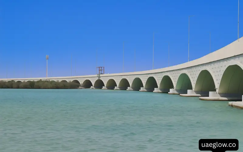
The project used arch-shaped structures to help maintain water flow and navigation channels. Officials also took steps to reduce the possible effect of the infrastructure on mangrove wetlands and marine life.
The bridge design allows water to continue moving through the area instead of blocking the waterways with a solid structure. This matters in coastal areas where water movement supports marine habitats.
Mangroves and Coastal Wetlands
Mangroves form an important part of Abu Dhabi’s coastal environment. They provide habitat for marine life and help support the natural coastal system.
The Umm Yifeenah Bridge project included environmental measures to reduce its impact on nearby mangrove areas. Mangrove trees were also planted on nearby Jubail Island as part of the project’s environmental work.
This makes the natural setting an important part of the story of Umm Yifenah Island, even though the island itself is not marketed as a major nature tourism destination.
Marine Life and Water Channels
The bridge project also considered movement through the waterways. Its arch-shaped causeways help maintain navigation channels and allow marine animals to move through the water.
These features show why the bridge required more than a standard road design. The project had to connect Abu Dhabi’s road network while also working within a coastal environment.
Things to Do Near Umm Yifenah Island
Umm Yifenah Island does not have the same tourism profile as Yas Island, Saadiyat Island or other major Abu Dhabi visitor destinations.
The main points of interest are linked to the bridge, road network, walking and cycling infrastructure, waterways and surrounding areas. People interested in Abu Dhabi’s infrastructure may find the bridge particularly interesting.
Walking and Cycling
The dedicated walking and cycling paths provide options for people who want to travel without a car. These facilities form part of the bridge project and connect with Abu Dhabi’s wider active-transport plans.
Use only marked paths and follow local signs. Road bridges remain transport infrastructure, so safety should come first.
Photography
The bridge, waterways and Abu Dhabi skyline can provide interesting views for photography from permitted areas.
Do not stop on road lanes, access roads or restricted infrastructure areas to take photographs. Choose safe and designated places instead.
Exploring Nearby Abu Dhabi Islands
If you want a full day of sightseeing, nearby developed islands may offer more facilities and attractions than Umm Yifenah itself.
Saadiyat Island, Al Reem Island and other Abu Dhabi destinations have different uses, from residential communities to cultural and leisure areas. Choose the nearby destination based on the type of activity you want.
Is Umm Yifenah Island a Tourist Attraction?
Umm Yifenah Island is better known for transport infrastructure than for traditional tourism.
The island’s main public importance comes from the Umm Yifeenah Bridge and its place in the Mid-Island Parkway. The area also has environmental features, walking and cycling infrastructure, and connections to nearby islands.
You should not expect the island to offer the same range of hotels, restaurants, entertainment venues and tourist attractions found on major Abu Dhabi leisure islands.
This distinction helps avoid confusion when planning a visit. If your goal is to see the bridge, explore the wider island network or use walking and cycling infrastructure, the area may be relevant. If you want beaches, major attractions or family entertainment, other Abu Dhabi destinations offer more dedicated facilities.
Why Umm Yifenah Island Matters to Abu Dhabi
The island matters mainly because of its place within Abu Dhabi’s transport network. First, the Umm Yifeenah Bridge creates a strong road connection between Al Reem Island and Sheikh Zayed bin Sultan Street. This helps people move between important island and mainland routes.
Second, the bridge includes walking and cycling paths. This gives the project a role beyond car travel and supports Abu Dhabi’s wider plans for active transport.
Third, the bridge forms the first phase of the Mid-Island Parkway. The wider project aims to create better links between several major islands and mainland areas.
Finally, the project shows how Abu Dhabi combines road development with environmental planning. Engineers designed the water crossings to maintain water movement and navigation while reducing the effect on mangrove wetlands and marine life.
Umm Yifenah Island vs Other Abu Dhabi Islands
Different Abu Dhabi islands have different roles, so it helps to compare them by purpose rather than treating them as the same type of destination.
| Island | Main Character |
| Umm Yifenah Island | Transport and infrastructure |
| Al Reem Island | Residential and urban community |
| Saadiyat Island | Culture, tourism and leisure |
| Yas Island | Entertainment and leisure |
| Jubail Island | Residential and natural environment |
| Al Maryah Island | Business, retail and waterfront |
This comparison does not mean every island has only one purpose. It simply shows why Umm Yifenah has a different identity from Abu Dhabi’s better-known visitor destinations.
Things to Know Before Visiting Umm Yifenah Island
Check your route before travelling because Abu Dhabi’s road network continues to change as new projects open.
Use marked walking and cycling paths when available. Do not enter restricted road or construction areas, and avoid stopping in unsafe locations near highways or bridge approaches.
Do not assume that every waterfront area allows swimming, fishing or other water activities. The main official information about Umm Yifenah focuses on transport, connectivity, walking, cycling and environmental planning rather than beach tourism.
If you plan to explore nearby islands, check each destination separately for its current opening hours, parking rules and visitor facilities.
Final Facts About Umm Yifenah Island
Umm Yifenah Island is an important part of Abu Dhabi’s growing island and road network. Its identity is closely tied to the Umm Yifeenah Bridge, which opened in 2023 and created an 11-kilometre connection between Al Reem Island, Umm Yifeenah Island and Sheikh Zayed bin Sultan Street.
The island also sits within the wider Mid-Island Parkway plans, which aim to connect more parts of Abu Dhabi. For visitors, the main points to understand are its location, bridge access, walking and cycling facilities, nearby islands and coastal environment rather than expecting a traditional resort destination.
Must Visit: Tameem House Office Building Dubai: Location, Offices, Facilities and Transport
Bin Shabib Mall Dubai: Location, Shops, Services, Timings & Parking
FAQ’s
Is Umm Yifenah Island in Abu Dhabi?
Yes. Umm Yifenah Island is in Abu Dhabi, United Arab Emirates. It is closely connected with the Umm Yifeenah Bridge and the wider Mid-Island Parkway.
What is Umm Yifeenah Bridge?
Umm Yifeenah Bridge is an 11-kilometre road project that connects Al Reem Island, Umm Yifeenah Island and Sheikh Zayed bin Sultan Street. It has six lanes, with three lanes in each direction.
When did Umm Yifeenah Bridge open?
Umm Yifeenah Bridge opened on 9 February 2023. The project became the first phase of Abu Dhabi’s larger Mid-Island Parkway.
Can you walk or cycle on Umm Yifeenah Bridge?
The project includes dedicated walking and cycling paths, along with bike rental facilities. Users should stay on the designated paths and follow local safety signs.
Is Umm Yifenah Island a tourist attraction?
Umm Yifenah Island is mainly known for its transport infrastructure and its role in Abu Dhabi’s island connectivity. It does not have the same tourism profile as major leisure destinations such as Yas Island or Saadiyat Island.
